

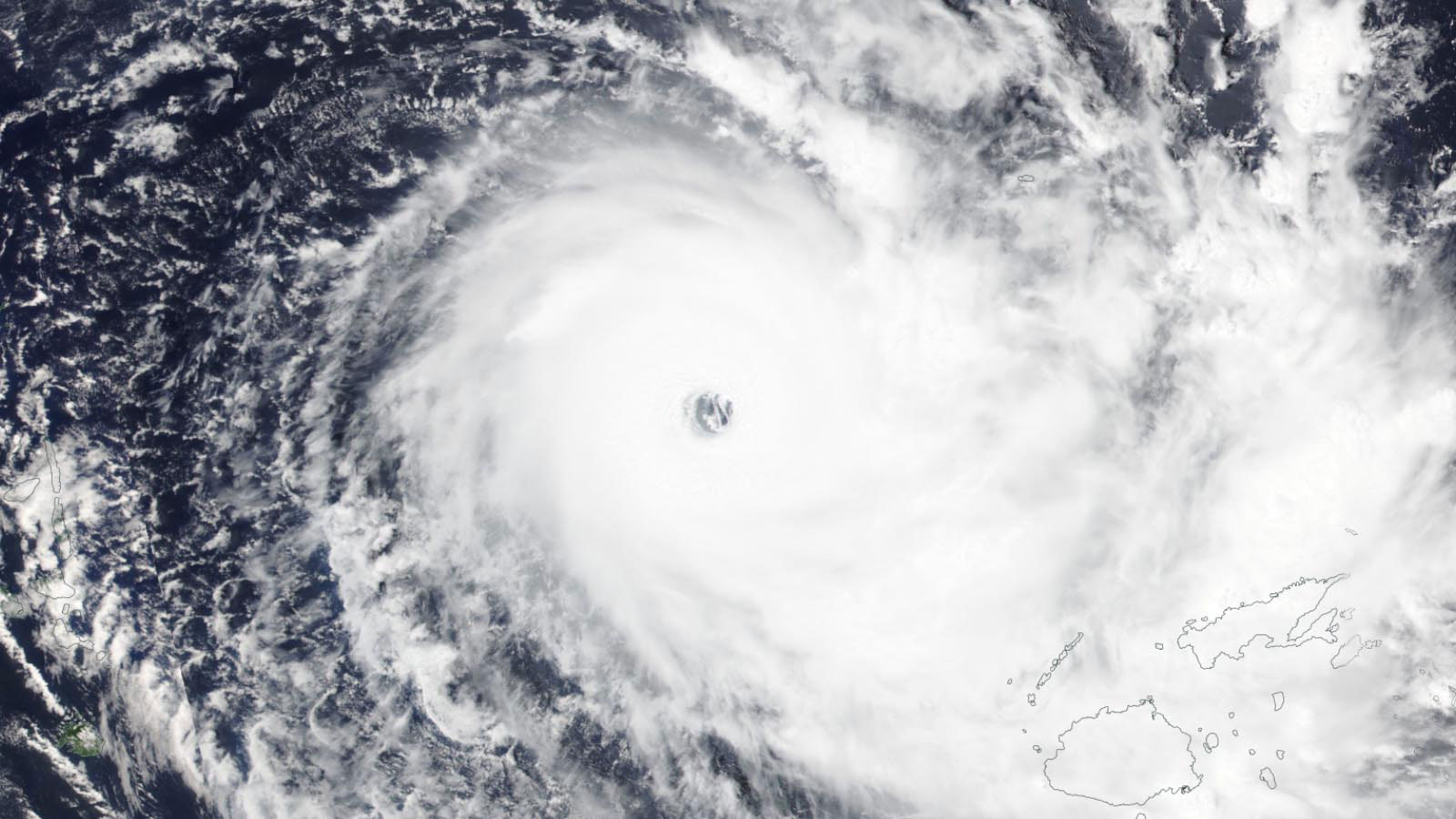
Fiji is bracing for the potentially catastrophic impact of category 5 Tropical Cyclone Yasa, which is expected to make landfall Thursday morning (U.S. EST) as a high-end category 4 storm. Fiji radar and satellite images show that Yasa had already begun pounding Fiji with heavy rains on Wednesday morning.
Yasa put on a very impressive burst of rapid intensification on Monday and Tuesday, its winds increasing by 65 mph in the 24 hours ending at 12Z Tuesday. Yasa peaked as a low-end category 5 storm with 160 mph winds with a central pressure of 914 mb at 0Z Wednesday, and maintained category 5 strength through 12Z Wednesday, according to the Joint Typhoon Warning Center (JTWC).

Forecast for Yasa
At 10 a.m. EST December 16, Yasa was headed east-southeast at 7 mph, on a track that will take it near or over the two main Fijian islands of Viti Levu (population 600,000) and Vanua Levu (population 136,000). The cyclone had favorable conditions for maintaining its intensity, with near-average ocean temperatures of 28-29 degrees Celsius (82-84°F) and light-to-moderate wind shear of 5-15 knots. However, the cyclone was undergoing an eyewall replacement cycle (ERC), a process common in intense cyclones, in which the eyewall shrinks, grows unstable, and collapses, with a new eyewall forming out of an outer spiral band. This process typically weakens a storm’s peak winds by 10-15 mph – though the region of ocean experiencing hurricane-force winds expands, resulting in a higher storm surge.
Given Yasa’s ERC and the generally favorable conditions for development, JTWC predicts that the cyclone will weaken slightly to category 4 strength with 145 mph winds when landfall in Fiji occurs early Thursday morning (U.S. EST). It is uncertain which of Fiji’s two main islands will receive the brunt of Yasa, and it is possible the cyclone will thread the narrow gap between them, resulting in severe but not catastrophic damage to Fiji.

The quality of the database that rates Cat 5s is too poor and the time series of decent data on these storms too short to make definitive conclusions about how climate change may be affecting these most fearsome of storms. However, climate change is expected to make category 5 storms stronger and more numerous in the coming decades.
Yasa is Earth’s fifth category 5 storm of 2020
Yasa is the second category 5 storm to be observed in the Southeast Pacific in 2020, joining Tropical Cyclone Harold, which devastated Vanuatu in April. In only one other year (1998) have two category 5 cyclones been observed in the Southeast Pacific. Since reliable satellite data for the Southeast Pacific became available in the 1980s, there have been 15 category 5 storms in the basin, as classified by the JTWC. Here is a list of the Southeast Pacific’s category 5 storms and their peak winds:
2002, Zoe, 180 mph;
2016, Winston, 180 mph;
2006, Monica, 180 mph;
2015, Pam, 175 mph;
2020, Harold, 165 mph;
1998, Ron, 165 mph;
2005, Olaf, 165 mph;
2020, Yasa, 160 mph;
1988, Anne, 160 mph;
1992, Fran, 160 mph;
1998, Susan, 160 mph;
2004, Heta, 160 mph;
2005, Percy, 160 mph;
2010, Ului, 160 mph; and
2014, Ita, 160 mph.
Yasa is the fifth category 5 storm on Earth in 2020, which is a near-average tally of these great storms for a year. Earth averaged 5.3 Category 5 storms per year between 1990 and 2019, according to ratings made by NOAA’s National Hurricane Center and the U.S. Navy’s Joint Typhoon Warning Center. Here are the Cat 5s in 2020:
Cyclone Harold, April 6, 165 mph winds (Southeast Pacific)
Cyclone Amphan, May 18, 165 mph winds (North Indian)
Super Typhoon Goni, October 30-31, 195 mph winds Northwest Pacific)
Hurricane Iota, November 15, 160 mph winds (Atlantic)
Cyclone Yasa, December 16, 160 mph winds (Southeast Pacific)

Fiji cyclone history
Only one previous category 5 cyclone has made landfall in Fiji: Tropical Cyclone Winston, which topped-out with 180 mph sustained winds at its peak intensity on February 20, 2016. These winds are tied for the highest for any Southern Hemisphere tropical cyclone ever rated by JTWC, along with Cyclone Zoe in 2002 and Cyclone Monica in 2006. Winston’s landfall on Koro Island in Fiji with 180 mph winds puts Winston in seventh place for Earth’s strongest landfalling tropical cyclone on record. According to insurance broker Aon, Winston killed 44 people in Fiji and did $1.4 billion (2016 dollars) in damage (32% of Fiji’s GDP), making it Fiji’s deadliest and most expensive cyclone in recorded history (note: EM-DAT puts Winston’s damage in Fiji at $600 million). Winston’s intensity was aided by ocean temperatures more than 1°C (1.8°F) warmer than average. Fiji’s second most expensive cyclone was Tropical Cyclone Kina in January 1993, with $167 million in damage (2016 dollars).
Website visitors can comment on “Eye on the Storm” posts (see below). Please read our Comments Policy prior to posting. (See all EOTS posts here. Sign up to receive notices of new postings here.)
Posted on December 16, 2020(1:33pm EST).
Topics: Weather Extremes
December 17, 2020 at 01:40AM
https://ift.tt/3oT9VXS
Tropical Cyclone Yasa expected to slam Fiji as category 4 storm - Yale Climate Connections
https://ift.tt/3bWFHgJ
Bagikan Berita Ini


0 Response to "Tropical Cyclone Yasa expected to slam Fiji as category 4 storm - Yale Climate Connections"
Post a Comment