

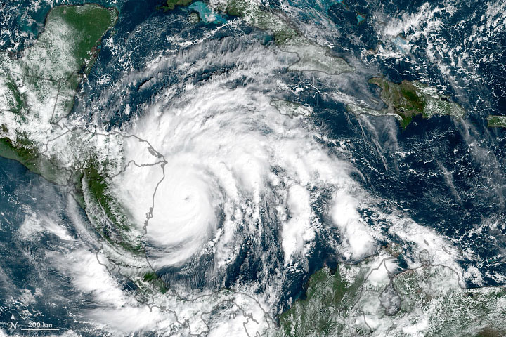
This year’s unrelenting hurricane season is still rolling, and Monday evening saw Hurricane Iota make landfall in Nicaragua as a Category 4 storm. Despite the official end of the Atlantic hurricane season being less than two weeks away, Iota actually became the strongest hurricane of the year when it reached Category 5 on Monday morning.
This is the first November on record to see two major (Category 3+) hurricanes, and it’s the latest any storm has hit Category 5. The only other November category 5 occurred in 1932, and that was in the first week of the month. Iota is the 30th named storm of 2020—also a record. Once the list of 21 storm names for the year is exhausted, subsequent storms are simply designated by Greek letters.
Here's how 2020 Atlantic #hurricane season ranks so far with other seasons in satellite era (since 1966) and with long-term average. Record-setting for named storms, 2nd for hurricanes & major hurricanes, 3rd for named storm days, 6th for Accumulated Cyclone Energy. #Iota pic.twitter.com/cjBlIIz5JP
— Philip Klotzbach (@philklotzbach) November 17, 2020
Iota made landfall near Puerto Cabezas in Nicaragua, bringing 155 mile-per-hour winds, rain, and storm surge. Unbelievably, this was just 15 miles south of the location Hurricane Eta made landfall (also as a Category 4) on November 3. This means many people who evacuated for Eta hadn’t even returned yet, but those who had were forced to evacuate again—amidst a pandemic.
Although Iota has weakened significantly over land, wind and rain are still a major concern. Up to 30 inches of rain fell nearer the coast, and NOAA’s National Hurricane Center is forecasting 10 to 20 inches in other portions of Nicaragua, Honduras, Guatemala, and Belize through Thursday. Areas of El Salvador and Panama could see “isolated maximum totals” reaching 12 inches.
The fact that this area was so recently soaked by Hurricane Eta is critical. The saturated soils won’t be able to absorb as much rain, turning more of it into overland runoff that can result in flooding. All this moisture also greatly raises the risk of landslides in steep terrain.
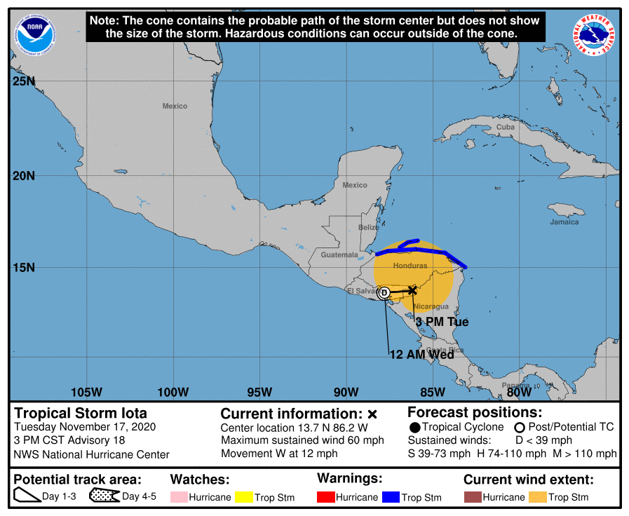
Iota is making its way westward and will reach the Pacific coast on Wednesday. As of Tuesday afternoon, Iota’s winds had weakened to about 60 miles per hour, reducing it to tropical storm status. It is forecast to further weaken to a tropical depression tonight, with wind speeds below 38 miles per hour, and it should lose even that status Wednesday.
Iota’s growth was fueled by warm sea surface temperatures in the region—where there is clearly a warming trend over time. Ocean temperatures and wind patterns have been particularly conducive this year, allowing for the prolific hurricane activity we have experienced.
NOAA’s hurricane season outlooks called for above-average activity way back in spring, and expectations were bumped up further in August. The continuing storm activity late in the season has pushed beyond even those expectations, however. The August outlook included 19-25 named storms, while we’ve now reached 30. It also included 7-11 hurricanes, while Iota checks in as number 13.
If 2020 has another named storm left in it before the season ends, the next name up would be Kappa.
November 18, 2020 at 06:49AM
https://ift.tt/3pHhkLs
Mid-November Hurricane Iota was the latest Category 5 on record - Ars Technica
https://ift.tt/3bWFHgJ
Bagikan Berita Ini


0 Response to "Mid-November Hurricane Iota was the latest Category 5 on record - Ars Technica"
Post a Comment