

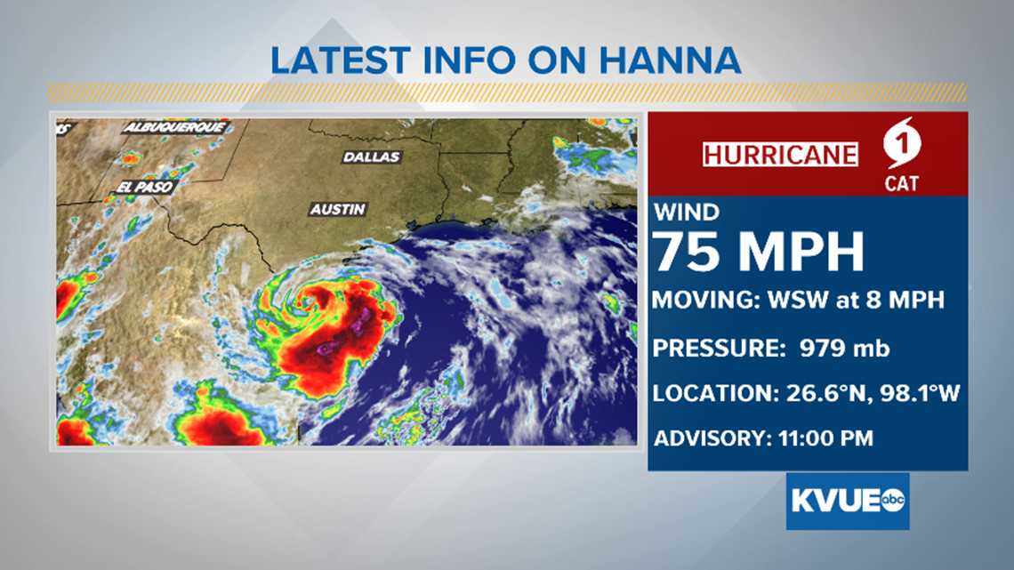
Hanna is the first hurricane to make landfall in the 2020 hurricane season and the first hurricane to make landfall in Texas since Harvey.
AUSTIN, Texas — After a day of strengthening, Hurricane Hanna made landfall on Padre Island just after 5 p.m. Saturday, with maximum sustained winds of 90 mph. After landfall on Padre Island, Hanna then moved inland over Kennedy County. Hanna is the first hurricane to make landfall in the 2020 hurricane season and the first hurricane to make landfall in Texas since Harvey.
Hanna is also the strongest hurricane to make landfall in Texas in the month of July since Hurricane Claudette in 2003, which also made landfall with winds of 90 mph.
On Friday, Gov. Greg Abbott issued a statement after the National Hurricane Center issued a Hurricane Warning and Storm Surge Warnings for several parts of the Texas Coast:
"As Tropical Storm Hanna approaches, Texans along the coast are advised to take precautionary measures to protect life and property,” said Gov. Abbott. "I urge all those who are in the path of this storm to heed the warnings and guidance from local officials before the storm makes landfall. The State of Texas will coordinate with local officials to provide assistance and resources to communities in the area."
Even as Hanna moves inland, the threat of wind, flooding, and storm surge continues for portions of south Texas where Hurricane Warnings remain in effect.
Ultimately, Hanna will continue to weaken as it moves inland, and Hanna is expected to dissipate over the higher terrain of northern Mexico on Monday.
Aside from the surge and wind threat, Hanna will also bring rain to much of Texas this weekend. With the center of the system now moving inland over South Texas, the heaviest rainfall totals will remain south of the KVUE area.
However, the northernmost feeder bands will mean tropical downpours are possible for Central Texas once again on Sunday. These tropical downpours could produce locally heavy rainfall, especially for areas southeast of Austin.
The lowest rainfall totals over the weekend will be across the Hill Country, where amounts from a quarter inch up to an inch will be possible including what has already fallen Saturday.
Heavier totals are more likely south and east of Austin where the outer bands will be more persistent. In these areas an inch to inch-and-a-half of rain is possible. Locally, higher numbers cannot be ruled out depending on where the outer bands set up.
In fact, some locations have already picked up over an inch of rain over Bastrop and Fayette counties as of Saturday evening.
The cloud cover and rain from Hanna will keep temperatures a bit cooler this weekend, with highs likely in the low 90s Sunday.
Hotter and drier weather is in the forecast by the middle of the upcoming week after Hanna dissipates over the mountains of northern Mexico.
The KVUE Storm Team will continue to monitor the forecast closely and will provide frequent updates. The extended forecast can be found below:
PEOPLE ARE ALSO READING:
July 23, 2020 at 11:10AM
https://ift.tt/2OUHE3l
Tropical Depression Eight has formed, expected to strengthen before making landfall - KVUE.com
https://ift.tt/3bWFHgJ
Bagikan Berita Ini


0 Response to "Tropical Depression Eight has formed, expected to strengthen before making landfall - KVUE.com"
Post a Comment